 |
| The retention pond at Wallace Swamp Creek Park in Kenmore, WA |
Thanks to a glorious break in this stretch of otherwise very rainy weather, Eric and I were able to get outside late yesterday afternoon and take a quick stroll through Wallace Swamp Creek park. You can see here the huge amount of water that we witnessed flowing out of the sediment pond located in the stretch of Swamp Creek that flows through the park. The water has actually carved a secondary exit through the berm to the left of the area where the water is supposed to flow out of the pond. Eric commented that we were actually watching the rainwater that fell on Everett and Lynnwood flowing by. Which reminded me....
 |
| from "North Creek and Swamp Creek Watershed Guidebook" by Snohomish County Public Works |
A friend of ours lent Eric this clever and information-packed booklet that she had used in her classroom. It's called "North Creek and Swamp Creek Watershed Guidebook", and it was put out by Snohomish County Public Works some time ago (no date in it anywhere, unfortunately). It is packed with great watershed guidelines and information, but what I couldn't wait to share is this particular page that shows the huge area that makes up the Swamp Creek watershed. (Click on the photo to pop out a larger version in a new page)
All of the area in that map drains into Swamp Creek and ends up flowing through Kenmore.
So it should be no surprise that there is flooding in the area around Swamp Creek in Kenmore when we have heavy rainfall. There is a huge urban area that is ultimately draining into Swamp Creek. Flooding is a watershed issue, but unfortunately it's the area furthest downstream that experiences the most dramatic cumulative effects of the combined stormwater runoff coming from upstream. Is it possible to convince (or force) our upstream neighbors to make changes going forward that will lower the amount of runoff that is hammering us down here? Planning for a future watershed forum is in the works, so hopefully a watershed-wide conversation can at least get started.
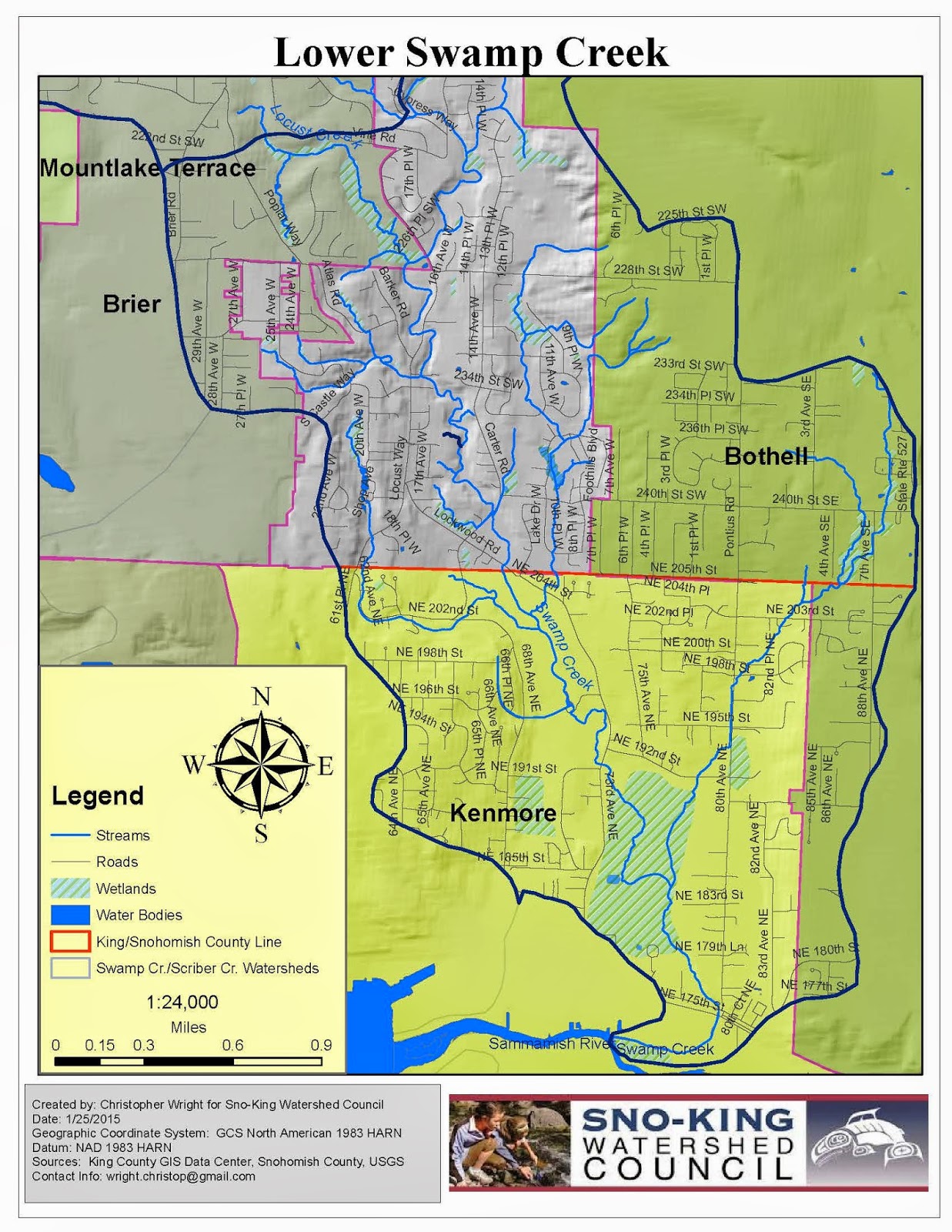
Here are some beautiful new informational maps created by Christopher Wright for the Sno-King Watershed Council and shared here courtesy of the Watershed Council (click on the maps to open them in a new page, where you can click on them to zoom in) --

.png)
.jpg)
And here is probably the best map of Little Swamp Creek and its watershed that I have seen, showing its headwaters in two different neighborhoods in the Canyon Park area of Bothell --

Someone is cutting trees and it looks like they are getting ready to develop right on Swamp Creek, by Carter Road and 235th Pl SW. Is that legal? I thought this was a protected watershed. This beautiful forest is being cut down across from Locust Park. sea4jam@gmail.com
ReplyDelete